b. An airspace of defined dimensions within which air traffic control service is provided to IFR flights and to VFR flights in accordance with the airspace classification. Controlled airspace is a generic term that covers Class A, Class B, Class C, Class D, and Class E airspace. Controlled airspace is also that airspace within which all aircraft operators are subject to certain pilot qualifications, operating rules, and equipment requirements in FAR Part 91 (for specific operating requirements, please refer to FAR Part 91). For IFR operations in any class of controlled airspace, a pilot must file an IFR flight plan and receive an appropriate ATC clearance. Each Class B, Class C, and Class D airspace area designated for an airport contains at least one primary airport around which the airspace is designated (for specific designations and descriptions of the airspace classes, please refer to FAR Part 71.
c. Controlled airspace in the United States is designated as follows:
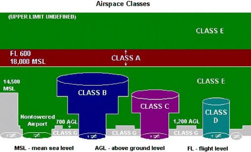
1. CLASS A (formerly PCA -Positive Control Area)
generally, that airspace from 18,000 feet mean sea level (MSL) up to and including flight level (FL) 600 (60,000 feet pressure altitude) , including the airspace overlying the waters within 12 nautical miles of the coast of the 48 contiguous States and Alaska. Unless otherwise authorized, all persons must operate their aircraft under IFR.
2. CLASS B (formerly TCA Terminal Control Area)
Generally, that airspace from the surface to 10,000 feet mean sea level (MSL) surrounding the nation's busiest airports in terms of airport operations or passenger enplanements. The configuration of each Class B airspace area is individually tailored and consists of a surface area and two or more layers (some Class B airspace areas resemble upside down wedding cakes), and is designed to contain all published instrument procedures once an aircraft enters the airspace. An ATC clearance is required for all aircraft to operate in the area, and all aircraft that are so cleared receive separation services within the airspace. The cloud clearance requirement for VFR operations is "clear of clouds."
3. CLASS C (formerly ARSA Airport Radar Service Area)
Generally, that airspace from the surface to 4,000 feet above the airport elevation (charted in mean sea level (MSL)) surrounding those airports that have an operational control tower, are serviced by a radar approach control, and that have a certain number of IFR operations or passenger enplanements. Although the configuration of each Class C area is individually tailored, the airspace usually consists of a surface area with a 5 nautical mile (NM) radius, an outer circle with a 10 nm radius that extends from 1,200 feet to 4,000 feet above the airport elevation and an outer area. Each person must establish two-way radio communications with the ATC facility providing air traffic services prior to entering the airspace and thereafter maintain those communications while within the airspace. VFR aircraft are only separated from IFR aircraft within the airspace.
4. CLASS D (formerly ATA Airport Traffic Area and CZ Control Zone)
Generally, that airspace from the surface to 2,500 feet above the airport elevation (charted in mean sea level (MSL)) surrounding those airports that have an operational control tower. The configuration of each Class D airspace area is individually tailored and when instrument procedures are published, the airspace will normally be designed to contain the procedures. Arrival extensions for instrument approach procedures may be Class D or Class E airspace. Unless otherwise authorized, each person must establish two-way radio communications with the ATC facility providing air traffic services prior to entering the airspace and thereafter maintain those communications while in the airspace. No separation services are provided to VFR aircraft.
5. CLASS E (formerly General Controlled Airspace)
Generally, if the airspace is not Class A, Class B, Class C, or Class D, and it is controlled airspace, it is Class E airspace. Class E airspace extends upward from either the surface or a designated altitude to the overlying or adjacent controlled airspace. When designated as a surface area, the airspace will be configured to contain all instrument procedures. Also in this class are Federal airways, airspace beginning at either 700 or 1,200 feet AGL used to transition to/from the terminal or enroute environment, enroute domestic, and offshore airspace areas designated below 18,000 feet mean sea level (MSL). Unless designated at a lower altitude, Class E airspace begins at 14,500 feet mean sea level (MSL) over the United States, including that airspace overlying the waters within 12 nautical miles of the coast of the 48 contiguous States and Alaska, up to, but not including 18,000 feet mean sea level (MSL), and the airspace above flight level (FL) 600.